


$2,000.00
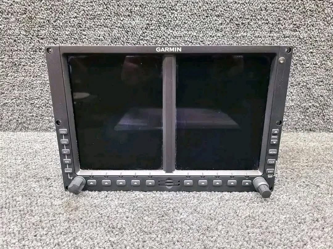
The Garmin G500 Flight Display System is a sophisticated glass cockpit retrofit solution designed to bring advanced situational awareness, navigation capabilities, and enhanced flight information to a wide range of general aviation aircraft. Engineered to replace traditional analog flight instruments, the G500 combines cutting-edge avionics technology with an intuitive interface, helping pilots improve safety, efficiency, and overall flight performance. Garmin G500 Flight Display System
Developed by Garmin, a globally recognized leader in aviation electronics, the G500 Flight Display System delivers comprehensive flight information through two high-resolution displays that provide pilots with critical data in an easy-to-read format. Whether operating in visual meteorological conditions (VMC) or instrument flight rules (IFR) environments, the G500 offers a reliable and feature-rich platform that enhances decision-making and reduces pilot workload. Garmin G500 Flight Display System
At the heart of the Garmin G500 system are two vibrant, sunlight-readable LCD screens that serve as the Primary Flight Display (PFD) and Multi-Function Display (MFD). The PFD presents essential flight information such as attitude, airspeed, altitude, vertical speed, heading, and navigation guidance in a modern electronic format. The MFD provides moving maps, terrain awareness, traffic information, weather overlays, flight plan details, and other valuable operational data.
The dual-screen configuration enables pilots to access critical information quickly without the need to scan multiple analog gauges. This streamlined presentation enhances situational awareness and allows for more effective monitoring of aircraft performance and surrounding conditions. Garmin G500 Flight Display System
One of the key advantages of the Garmin G500 Flight Display System is its ability to provide superior situational awareness. The system integrates data from various onboard sensors and compatible avionics systems to create a comprehensive picture of the aircraft’s operating environment.
The moving map display offers detailed terrain, airspace boundaries, airports, navigation aids, and flight routes. Pilots can visualize their position in real time while maintaining awareness of nearby obstacles and terrain features. This capability is especially beneficial during cross-country flights, approaches, and operations in unfamiliar airspace.
Terrain awareness functionality helps identify potential hazards by graphically displaying terrain relative to the aircraft’s altitude. Color-coded terrain alerts assist pilots in recognizing possible conflicts before they become critical, contributing to safer flight operations.
The G500 is designed to integrate seamlessly with a broad range of Garmin avionics products, creating a highly capable and interconnected cockpit environment. It works effectively with Garmin GPS navigators, communication radios, transponders, autopilot systems, traffic advisory systems, and weather receivers.
When paired with compatible Garmin navigators, the G500 can display flight plans, navigation guidance, instrument procedures, and approach information directly on the screen. This integration minimizes the need for pilots to reference multiple devices and allows for more efficient cockpit management.
The system can also interface with Garmin’s advanced autopilot solutions, enabling smoother flight operations and reducing pilot workload during en-route and approach phases of flight.
A standout feature available with the Garmin G500 Flight Display System is Synthetic Vision Technology (SVT). This innovative capability creates a three-dimensional representation of terrain, obstacles, runways, and other environmental features directly on the Primary Flight Display.
Synthetic Vision provides pilots with an intuitive visual reference even in low-visibility conditions, nighttime operations, or challenging weather environments. By presenting a realistic depiction of the surrounding landscape, SVT enhances spatial orientation and supports safer flight operations.
The system displays terrain contours, airport runways, towers, and other critical features, helping pilots maintain awareness of their environment when outside visual references may be limited.
The Garmin G500 supports integration with traffic and weather systems that provide real-time operational data. Traffic information can be displayed directly on the Multi-Function Display, helping pilots identify nearby aircraft and maintain safe separation.
Weather overlays can include radar imagery, METAR reports, TAF forecasts, lightning information, and other meteorological data depending on the connected equipment. Access to comprehensive weather information enables pilots to make informed decisions regarding route planning, altitude selection, and diversion options.
These capabilities contribute significantly to flight safety and operational efficiency, especially during long-distance flights and changing weather conditions.
Garmin designed the G500 with pilot usability in mind. The intuitive interface allows for efficient operation while minimizing distractions during critical phases of flight. Clearly organized menus, dedicated control knobs, and logical navigation structures make it easy for pilots to access essential functions quickly.
The display layout can be customized to suit individual preferences and operational requirements. Important flight data remains prominently visible, ensuring that critical information is always available when needed.
The system’s ergonomic design helps reduce workload and supports smoother transitions for pilots upgrading from traditional analog instrumentation.
Garmin products are widely respected for their reliability, and the G500 Flight Display System is no exception. Built to withstand the demanding conditions of aviation operations, the system delivers dependable performance across a wide range of flight environments.
The solid-state architecture minimizes moving parts and enhances overall system durability. In addition, electronic displays reduce maintenance requirements commonly associated with aging mechanical flight instruments.
Many aircraft owners choose the G500 as part of a comprehensive avionics modernization program, benefiting from improved reliability, reduced maintenance concerns, and increased aircraft value. Garmin G500 Flight Display System
The Garmin G500 was specifically developed as a retrofit solution for existing aircraft, making it an attractive option for owners seeking to modernize their cockpit without purchasing a new aircraft. The system has been installed in numerous certified aircraft models and continues to be a popular upgrade among private pilots, business operators, and flight training organizations. Garmin G500 Flight Display System
Replacing legacy instruments with the G500 can dramatically transform the flying experience by providing modern capabilities comparable to those found in newer aircraft. Enhanced situational awareness, improved navigation functionality, and increased operational efficiency make the upgrade highly beneficial for a wide variety of missions.
The Garmin G500 Flight Display System represents a significant advancement in cockpit technology for general aviation aircraft. Combining a high-resolution Primary Flight Display, versatile Multi-Function Display, synthetic vision capabilities, terrain awareness, traffic monitoring, weather integration, and seamless compatibility with Garmin avionics, the G500 delivers a comprehensive flight management solution. Garmin G500 Flight Display System
Designed to improve safety, reduce pilot workload, and enhance situational awareness, the Garmin G500 continues to be a trusted choice for aircraft owners and operators seeking a modern glass cockpit experience. With its proven reliability, intuitive operation, and powerful feature set, the G500 remains one of the most respected flight display systems in the aviation industry. Garmin G500 Flight Display System

Reviews
There are no reviews yet.